
When to Hike the Michinoku Coastal Trail
Last updated: September 2026
For most hikers, spring and autumn are the best times to walk the Michinoku Coastal Trail. Given a free choice, I'd aim for late April through May, or October into early November: comfortable temperatures, the landscapes at their best, and much less of the summer heat.
That doesn't mean the trail shuts down the rest of the year. The MCT follows Japan's Pacific coast, and unlike the snowier mountains and Sea of Japan side of Tohoku, much of it can be walked year-round. Even winter can be surprisingly good. The Michinoku Coastal Trail Association (MCTA) describes winter and early spring hiking as generally possible along the coast, while warning about snow and ice on higher sections and seasonal facility closures.
This is a trail stretching more than 1,000 km from Fukushima to Aomori, though, so there's no single perfect month everywhere at once. Your ideal season depends on where you're walking, whether you're camping, and whether you're section-hiking or thruhiking.
Planning your first MCT trip? Start with Plan the Michinoku Coastal Trail, then come back here once you've narrowed down your dates.
Late April to May · October to early November
For most hikers, these are the two strongest windows for comfortable walking.
March to May
June to July
Mid-July to August
September to November
December to February
Seasons overlap and conditions vary from year to year. On a trail this long, weather can also differ significantly between Fukushima and northern Iwate or Aomori.
Spring: March to May
One of the best times to walk
Spring is probably my first choice for a long MCT trip. Temperatures gradually warm, daylight increases, forests and coastal meadows come back to life, and Tohoku's cherry blossom season arrives later than Tokyo and southern Japan. April and May are particularly good.
March is more complicated. The southern sections around Fukushima and Miyagi may already be very walkable, while northern and higher sections can still see snow, ice and freezing overnight temperatures. Snow can remain on mountain sections even into April.
One advantage of the MCT's length is that spring moves north with you. A hiker starting in the south can gradually follow the season toward Aomori.
If flowers are part of the appeal, don't focus only on cherry blossoms (sakura). The Tanesashi Coast becomes increasingly colourful through May and early summer, with coastal wildflowers and its famous natural grasslands overlooking the Pacific.
Early in the season, watch for cold mornings, strong coastal winds, lingering snow or ice on higher northern sections, and campsites that may not yet have opened.
Cherry Blossom (Sakura) Season
The Tohoku region’s sakura will generally bloom a bit later than Tokyo, so make sure you check the cherry blossom forecast if you’re planning to go around Spring time, like this one below from 2026. If you get the timing right, you could be in for an unforgettable few weeks of walking!
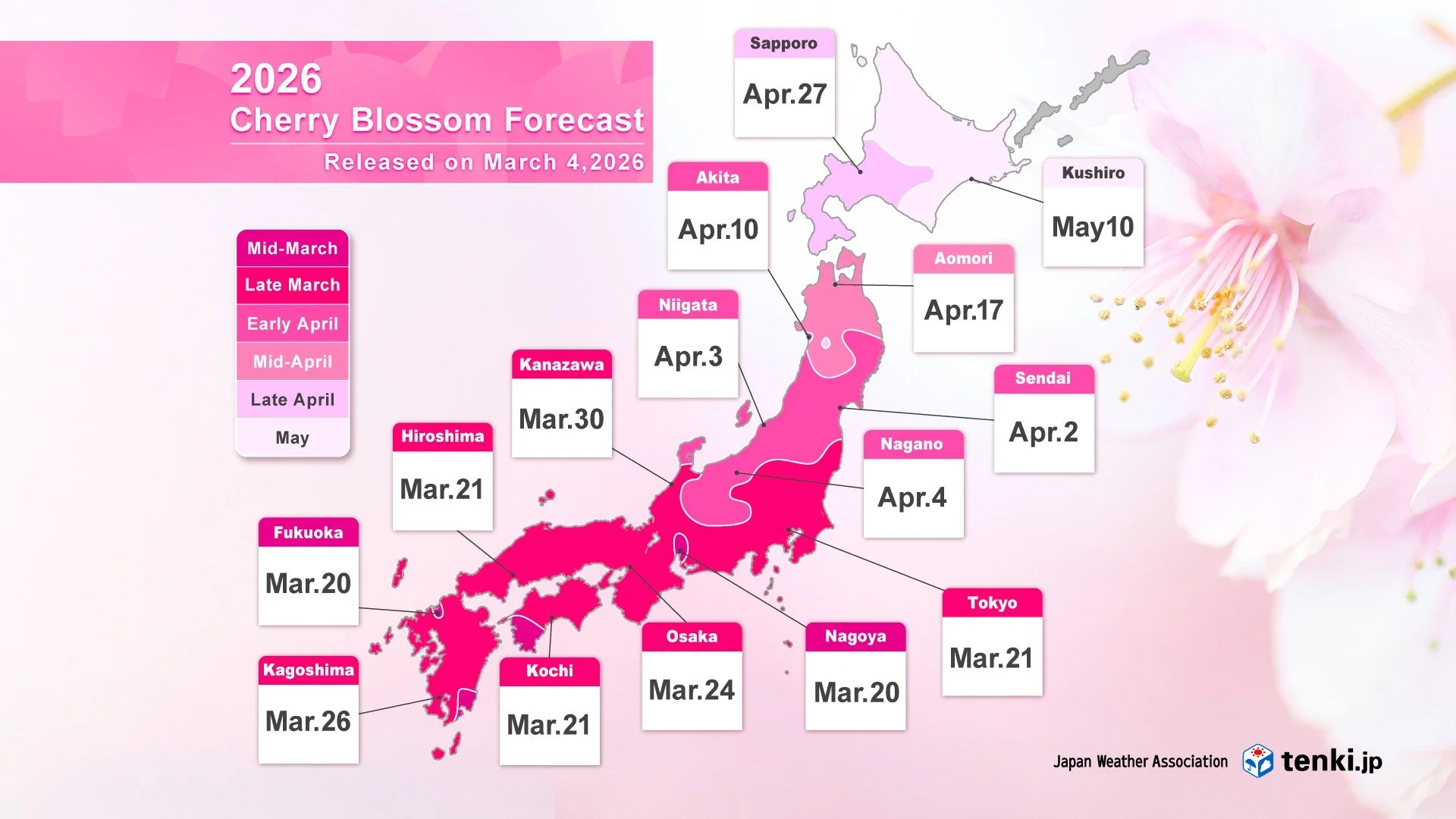
Source: Japan Weather Association
Rainy Season: June to July
Very green. Sometimes very wet.
Japan's rainy season, tsuyu, reaches Tohoku later than most of the country. Based on Japan Meteorological Agency climate normals, it typically begins around 12 June in southern Tohoku and 15 June in northern Tohoku, ending around 24 to 28 July. These are averages rather than dates to rely on in any given year.
This doesn't mean it rains continuously for six weeks. You can get beautiful walking days.
But multi-day rain is entirely possible, and it matters more here than on a city trip. Natural trails become slippery, river levels can rise, and storms can affect ferries and coastal sections.
There's also the yamase, a cool, damp easterly wind that can affect the Pacific side of northern Japan in summer, bringing surprisingly cool temperatures, cloud and fog even when inland Japan is hot. If you're walking during this period, proper rain gear is worth every gram. See Packing for the MCT and MCT Safety before setting out.
Summer: Mid-July to August
Beautiful, lively and hotter than you might expect
Summer has plenty going for it: long days, an extremely green coast, open swimming beaches, festivals across Tohoku, and some of the Sanriku coast's best-known seafood in season.
But for long-distance hiking, heat and humidity are the problem.
A large proportion of the MCT involves paved roads and exposed coastal walking. On a sunny summer day, those kilometres get considerably harder than they look on a map. Carry plenty of water and sun protection.
The north also has an odd summer contradiction: hot and humid one day, then a yamase wind bringing fog, damp air and much cooler temperatures the next. Bring a light layer and rain protection even when the forecast looks summery.
Water planning matters much more at this time of year, so see Food, Water & Resupply.
Insects do too. Hornets become more active later in summer, ticks are present, and leeches can be a nuisance on humid forest sections. Repellent earns its weight.
What About Typhoons?
Typhoons can affect Japan through summer and autumn, but late summer and September deserve particular attention. Long-term JMA statistics show tropical cyclone activity affecting Japan concentrated most heavily from July through October, with September particularly relevant to Tohoku.
That doesn't mean you should avoid the MCT throughout September. It means you should build some flexibility into a longer itinerary.
A typhoon can cancel ferries, raise rivers, bring dangerous coastal conditions, fell trees and temporarily close natural trails. Avoid entering mountain or forest sections during or immediately after severe weather.
For a long walk in August or September, I'd allow some slack in your itinerary rather than booking every day so tightly that bad conditions force your hand.
Autumn: September to November
Possibly the best hiking season of all
Autumn is the other outstanding window for the MCT.
September can still feel like summer, particularly further south, and still carries typhoon risk. By October, though, temperatures generally become much more comfortable and the air often feels clearer and drier.
October would be very high on my list if I were choosing a shorter MCT trip.
Forests turn gradually through autumn, with colour appearing earlier in northern and higher areas and moving south as the season progresses.
The main trade-off is daylight. Sunset comes surprisingly early in northeastern Japan, and by November your walking day is considerably shorter than it was in May or June. Plan longer or more remote sections accordingly.
Autumn is also still wildlife season. Hornets are particularly active in late summer and early autumn, and bears are feeding heavily before winter. See Bears on the MCT and the broader MCT Safety Guide for current advice.
Winter: December to February
Much more possible than you might think
People often assume Tohoku means deep snow all winter. That's true in parts of inland Tohoku and on the Sea of Japan side. It is much less true along the Pacific coastline followed by the MCT.
Winter hiking here can be surprisingly good, with clearer views through leafless forest, crisp air, almost no mosquitoes or leeches, fewer visitors and no summer heat. I wouldn't recommend it as the easiest introduction to a long MCT hike, though.
Snow and ice can occur on mountain sections and northern nature trails. Days are short. Temperatures can fall below freezing overnight. Some campsites, outdoor water supplies and toilets shut for the season, and some seasonal transport stops running. Winter therefore works particularly well if you're section-hiking and staying indoors, rather than relying heavily on campsites.
One more thing to plan around is the Urato Islands. The dedicated MCT boat connecting the islands with Miyato runs only during the warmer part of the year. For the 2026 season, operations run from 15 April to 14 November. Always check the current schedule before finalising a boat-dependent itinerary.
See Accommodation on the MCT for places to stay and information on seasonal campsites.
A Note on Kinkasan and Leeches
If Kinkasan or the Oshika Peninsula is high on your list, season matters for another reason. Land leeches are a nuisance in the warmer months, particularly from May through October. Late autumn through early spring therefore has real appeal if avoiding them matters to you, although you'll still need to work around limited boat schedules and winter conditions.
See my Kinkasan Island hiking guide for the route and boat-planning details.
Thruhiking: Spring or Autumn?
For a full MCT thruhike, I'd generally choose either spring or autumn.
Spring: Consider Going Northbound
Starting around Fukushima in spring lets you begin in the warmer south and gradually move north as temperatures rise.
It also means reaching some of the spectacular northern Sanriku sections later in your hike as spring develops.
Autumn: Consider Going Southbound
Starting around Hachinohe in late September or early October lets you gradually move toward the warmer south as autumn progresses.
September still carries some heat and typhoon risk, while starting too late risks pushing the end of a roughly 52-day walk into winter, so there's a balance to strike.
Neither direction is mandatory. I've written a separate guide comparing the advantages of each: Northbound or Southbound on the MCT?
Section-Hiking? Choose the Season for the Section
You don't need to optimise the entire 1,000+ km trail. If you're walking for a day, weekend or week, you can be much more selective. Spring might mean flowers on the Tanesashi Coast. Summer might mean combining a coastal walk with beaches and festivals. October is excellent for forested northern Sanriku. Winter can work surprisingly well for lower, southern sections if you prefer crisp weather and indoor accommodation. Start with the MCT Routes Overview, choose the section that appeals to you, then work backwards from the conditions you want.
Before You Finalise Your Dates
Weather is only one part of choosing when to go. Check current trail alerts, confirm accommodation and campsite opening dates, verify any ferry or boat you're relying on, and look at the actual weather forecast shortly before you set out. Conditions change much faster than a guide like this can. For the rest of your planning, see Plan the MCT, Routes, Accommodation, Packing, Food, Water & Resupply, Maps & Navigation, and Safety below.